
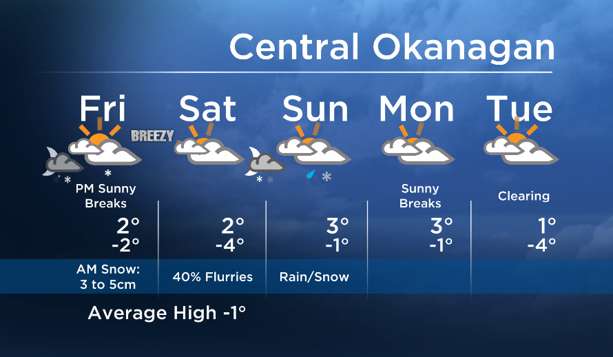
Weather update: Friday January 16th 7:50am

Good morning! With temperatures on both side of zero this morning through the valley, some areas are waking up to snow and others are not.
Check out the webcams and it’s easy to see where it’s milder and drier, and where it’s snowing.
South Okanagan regions near the lake stayed above freezing through the night and any precip that has moved through that area has been falling as a snow/rain mix or wet flurries. Some areas in the Shuswap are also seeing mixed precipitation this morning.
Many parts of the Central and North Okanagan have seen surface temperatures at freezing of slightly below and the snow has been sticking.


All areas will see a drier trend this afternoon. Some of us might even be so lucky to see some sunny breaks later today!
Mostly dry tomorrow with just a slight chance of precip as Saturday’s disturbance is weak, however, a stronger system is on deck again on Sunday with the chance of rain/snow again.
Today’s daytime high range: -2 to +4
~ Duane / Wesla
- Trudeau says ‘good luck’ to Saskatchewan premier in carbon price spat
- Canadians more likely to eat food past best-before date. What are the risks?
- Hundreds mourn 16-year-old Halifax homicide victim: ‘The youth are feeling it’
- On the ‘frontline’: Toronto-area residents hiring security firms to fight auto theft
Comments