
TORONTO – It’s been a mild summer for British Columbia, Alberta and parts of Atlantic Canada, but for other regions including Ontario and the eastern prairies, summer has been below seasonal with above-normal rainfall.

Remember, this comes after the coldest winter in decades across this same general area.

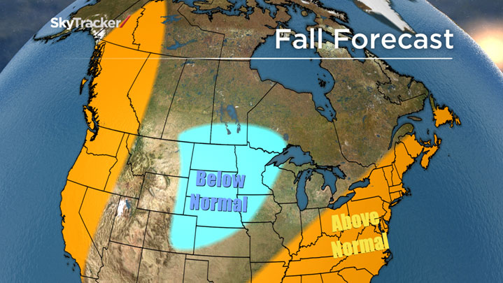
Fall Temperature Forecast
Our fall forecast predicts a continuation of slightly below-normal temperatures through the prairies in September and October, with a big drop-off possibly in November as a wintery pattern may set up early again this year.
READ MORE: Forecasters have higher expectations for slow Atlantic hurricane season
There is some good news for the rest of Canada: Warmer-than-normal ocean water is situated right off the west and east coast, favouring warmer-than-normal temperatures, at least for September and October.
Rainfall will continue to be above normal in Manitoba and Saskatchewan, with drier conditions along the west coast, in Ontario and Quebec this fall.
For Atlantic Canada, the warm water will need to be watched carefully in September and October because any threatening hurricanes would maintain intensity further north than normal. This could also bring locally heavier rainfall and flooding.
Water temperatures are well above normal just off the Atlantic Canada coast and in the Pacific off the B.C. coast.


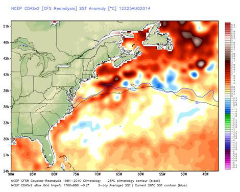


If this same water temperature pattern holds through the winter, we may be in for another long, frigid one in the middle of Canada. The Maritimes may not be as cold, but an active Nor’easter storm track would likely develop during the heart of the winter.
The big wild card for winter involves the tropical Pacific Ocean. A weak to moderate El Nino (warm water in the equatorial Pacific) is forecast to develop, which could alter the jet stream patterns around the globe.
If the El Nino is stronger than expected, then a robust southern jet of warm air would likely make the winter much warmer and wetter across most of North America.
READ MORE: Maybe we won’t get a milder winter: Forecasters reduce chance of El Nino
In 1998, the massive eastern Ontario, southern Quebec and New Brunswick ice storm was partially caused by an intense El Nino. If the El Nino ends up weaker than forecast, a winter similar to last year could occur.
Winter is still months away but even the thought of a repeat winter will have most Canadians cherishing every mild sunny fall day.
To get real-time weather for your area, download the Global News Skytracker weather app.
Comments